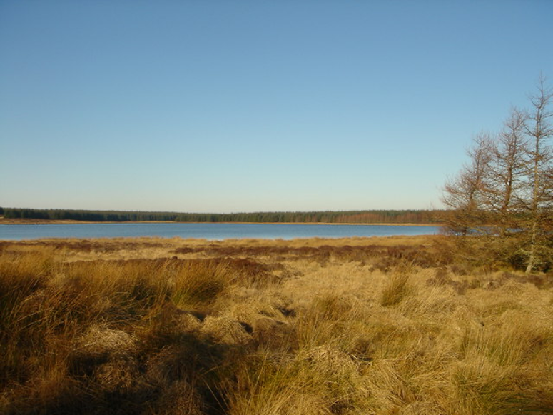
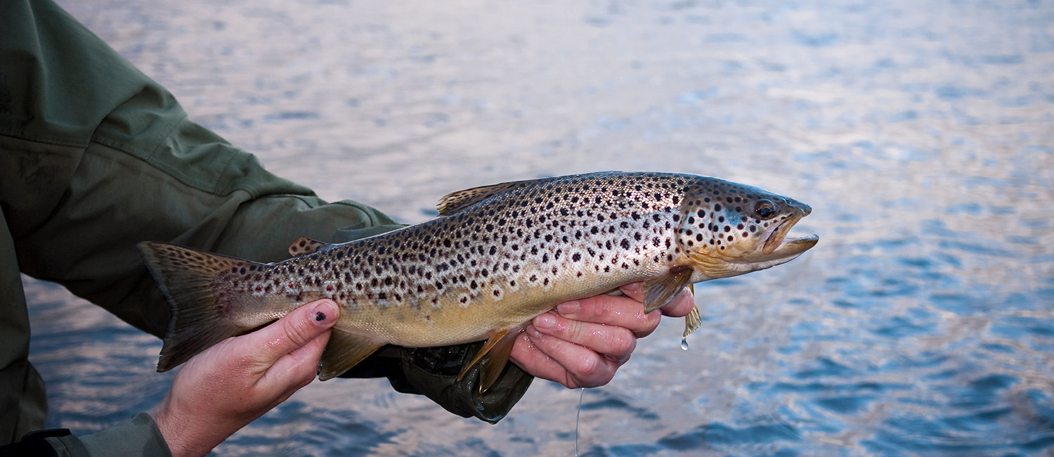
Fishing season 1st April to 5th October.
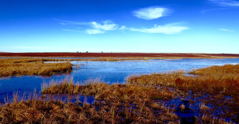
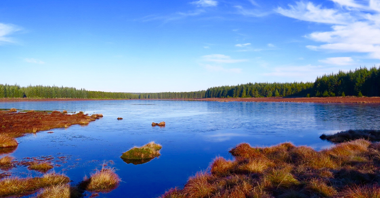
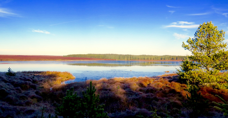
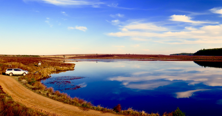
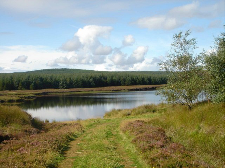
Loch Saorach
Grid Reference: 016 604
Elevation: 110m
Bag Limit: Catch and release.
Information coming soon!
Fishing season 1st April to 5th October
Grid Reference: 016 604
Elevation: 110m
Bag Limit: Catch and release.
Information coming soon!
Grid Reference: 009 603
Elevation: 110m
Bag Limit: Catch and release.
Information coming soon!
Grid Reference: 001 477
Elevation: 167m
Bag Limit: 6 Fish limit (9″ inch minimum).
Leave the A897 at Grid reference 903485 (Forsinain) and follow the forestry track, a 4×4 or vehicle with high clearance is required to negotiate the bumpy track, to park at 002 470. Head North for a distance of 500m to reach the loch. Nam Breac is a pleasant little lochan to the west of Skyline, useful for restoring confidence if the skyline trout are proving difficult. Sheltered to the east by forestry, but open to the north and west, Nam Breac is a shallow loch with comfortable wading from the southern and eastern banks. The west bank is very soft and should be avoided. Don’t expect anything for the glass case but a good head of small but spirited fish should keep the angler entertained.
Grid Reference: 800 471
Elevation: 217m
Bag Limit: 6 Fish limit (9″ inch minimum).
Leave the A897 at grid reference 891 437 and follow the forestry track for a distance of 5.5 miles to park at 819 471. A 4×4 or vehicle with high clearance is required to negotiate the bumpy track. Walk west for a distance of 1.55km to reach the loch. Saobhaide is a delightful loch in the heart of the flow country, guarded to the south by the Beinn Griam Mountains. There are many inviting bays and promontories to keep the angler interested and trout average 6/8 oz. Large baskets are the norm.
Grid Reference: 917 506
Elevation: 167m
Bag Limit: 6 Fish limit (9″ inch minimum).
Leave the A897 at Grid reference 901 495 follow the forestry track, a 4×4 or vehicle with high clearance is required to negotiate the bumpy track, to park at 913 507. Walk a further 300m east to reach the loch. Fish can be caught all over this small loch with trout averaging 10oz. The area around the small island can be productive.
Grid Reference: 975 474
Elevation: 166m
Bag Limit: All fish to be taken and accurate lengths recorded.
Leave the A897 at Grid reference 903485 (Forsinain) and follow the forestry track, a 4×4 or vehicle with high clearance is required to negotiate the bumpy track, to park at 974 459. Head North over wet ground for a distance of 1.2km to reach the boat in the SW corner of the loch which is free to use for all members. Club members have reduced the numbers of fish in this loch which has significantly improved the fishing and the habitat. Cloiche is a delightful loch and has a good head of bright, spirited, free rising fish in the 10-12oz bracket. Bigger fish of 1lb have been caught close to the bank, no doubt feeding on the numerous sticklebacks in the loch. Boat and bank both yield good catches, though care is needed when wading over rocky patches on the east side. All fish caught must be removed and lengths from the tip of nose to the fork in the tail accurately recorded and a catch return completed.
Grid Reference: 030 468
Elevation: 155m
Bag Limit: Catch and Release
Approach from Forsinain via forestry track leading to and beyond Altnabreac. 4×4 or vehicle with high clearance is required to negotiate the bumpy track. Continue along track past Loch Caise for 1/2 mile where a sign for Grassie will be found pointing through a forestry ride. A short 5 minute walk through this very wet and boggy ride will bring anglers to the southerly shore – waders are recommended to ensure dry feet! Anglers will encounter fewer fish in the loch’s considerable amount of shallow water in the westerly bay which reaches towards loch Caise, the deeper water extending along the opposite shore will produce most success. A fantastic little loch to visit and combine with either of the nearby lochs for added variation to the day. Grassie holds a smaller head of fish than neighbouring Garbh or Caise but trumps them both on size and quality with fish of over a pound often encountered.
Grid Reference: 872 614
Elevation: 133m
Bag Limit: Catch and Release
Leave the A836 Thurso/Bettyhill road at Grid reference 868651 and follow the road south. This is a rough track so a 4×4 will be necessary to drive to the end and park at 859626. Walk SE for a distance of approximately 1.8km to reach the loch. This loch has been seldom visited in recent times so little is known about the quality of fishing. Historical records have shown fish of over 2lbs being caught in the past, well worth a visit for the determined, adventurous angler.
Grid Reference: 870 623
Elevation: 132m
Bag Limit: Catch and Release
Leave the A836 Thurso/Bettyhill road at Grid reference 868651 and follow the road south. This is a rough track so a 4×4 will be necessary to drive to the end and park at 859626. Walk ESE for a distance of approximately 1km to reach the loch. This loch has been seldom visited in recent times so little is known about the quality of fishing. Historical records have shown fish of over 2lbs being caught in the past, well worth a visit for the determined, adventurous angler.
Grid Reference: 857 612
Elevation: 153m
Bag Limit: 6 Fish limit (9″ inch minimum)
Leave the A836 Thurso/Bettyhill road about 600 meters west of Melvich at grid reference 868651. A gate code must be obtained to access the track that you follow south for about 4 or 5km. This is a rough track so a 4×4 will be necessary to drive to the end and park at 859626. Walk in a southerly direction, past Loch Baligill, keeping to the high ground for a distance of 1.2km.
Loch Achridigill is a very productive loch for all fishing levels. A boat which will be found on the NW shore is available if booked in advance, otherwise a rocky shoreline requires careful wading but the rocks hold many trout very close in from 6oz to 10oz with the odd larger fish further out. The loch level used to be several feet higher and the east end is shallow and studded with rocks so be very careful when boat fishing. Bags of 50+ may be caught and fish may be kept for the pot.
Grid Reference: 856 620
Elevation: 153m
Bag Limit: Catch and Release
Leave the A836 Thurso/Bettyhill road about 600 meters west of Melvich at grid reference 868651. A gate code must be obtained to access the track that you follow south for about 4 or 5km. This is a rough track so a 4×4 will be necessary to drive to the end and park at 859626. Walk south and west over the hill a distance of approximately 800m, and the view opens up to reveal lochs Baligill and Ackridigill to the south with the Orkney Islands also visible over the North Sea on a clear day.
Loch Baligill is one of the most challenging of club waters with some steep banks After it was dammed for the local water supply in the late 1970s, there were a few good years of large trout taken from 2lbs to 3.5lbs with one exceptional fish landed in the 1980s of over 8lbs (believed to be the record trout for club waters). However, it is rare to find any other entries of trout over 3lbs in the old game books and in recent years (since the 1990s) very little if any fish have been caught here, although some have been seen on warm, calm evenings. Nothing is known about the best approach to fish this loch but it is certainly one for the hardy specimen hunter and worth a cast when tied in with a trip to the very productive loch Ackridigill. Expect more blanks than productive days – catch-and-release only.
Grid Reference: 039 452
Elevation: 144m
Bag Limit: Catch and Release
Leave the A897 at Grid reference 903485 (Forsinain) follow the forestry track, a 4×4 or vehicle with high clearance is required to negotiate the bumpy track, to park at 043455. Follow the fence line/forest ride for a 300m walk to reach the loch. The very southern part of the loch is shallow and wading is safe and advantageous though the angler is better off staying on the bank on the east and west banks. The east bank has proved to be productive in the past though fish have been caught all over the loch. Due to the nature of this loch it is unlikely to hold a large head of fish, expect fish in the region 10oz-1lb though don’t be surprised by something significantly larger!
Grid Reference: 036 468
Elevation: 147m
Bag Limit: 6 Fish limit (9″ inch minimum)
Grid Reference & Parking 12/036468. Approach from Forsinain via forestry track leading to and beyond Altnabreac. 4×4 or vehicle with high clearance is required to negotiate the bumpy track. Park in small trackside area opposite sleeper built footbridge. A short 3-4 minute walk north over tussocks and uneven ground will bring anglers to the loch’s southerly shore, boat users should follow the loch a couple of hundred yards around the east shore to find the boat mooring. Loch Garbh, with its large head of spirited, free rising fish in the 9″-12″ region is the perfect place to introduce anyone to fly fishing. Boat and bank both yield good catches, though care is needed when wading over rocky patches on west side.
Grid Reference: 025 466
Elevation: 153m
Bag Limit: 6 Fish limit (9″ inch minimum)
Grid Reference & Parking 12/023467. Approach from Forsinain via forestry track leading to and beyond Altnabreac. 4×4 or vehicle with high clearance is required to negotiate the bumpy track. Both bank and boat fishing is available on this little gem of a loch, and with loch side parking in the SW corner, this is one of the most delightful pieces of water an angler could visit. Fat, brightly marked, little fish rise readily and give a good account of themselves in the process. With the exception of the less productive west bank, fish are caught all around the loch in good numbers, larger concentrations are often encountered in both the north and south ends.
Grid Reference: 922 604
Elevation: 134m
Bag Limit: 6 Fish limit (9″ inch minimum)
Follow A897, Melvich to Helmsdale road, parking in area on the north side of cattle-grid just before electrical substation Grid reference 904599. Akran is an energetic 2km walk. Pass through the double gate, head uphill and along argo track ensuring forestry is to the left of the track. Pass through the gate and follow the route of the pylons to reach the NW bank of the loch. Akran is a good beginners loch, wading is safe with a large head of free rising fish, average size 8oz with the occasional bigger fish.
Grid Reference: 921 617
Elevation: 143m
Bag Limit: 6 Fish limit (9″ inch minimum)
Follow A897, Melvich to Helmsdale road, parking in area on the north side of cattle-grid just before electrical substation Grid reference 904599. Caol is an energetic 2.2km walk. Pass through the double gate, head uphill and along argo track ensuring forestry is to the left of the track. Pass through the gate and follow the route of the pylons to pass Loch Akran on your right, walk a further 400m then head north a further 250m to reach the loch. Caol is historically known as ‘Champagne’ nobody is sure of the reason why, perhaps successful anglers celebrated in style! Little is known about the fishing in this loch though historical records show fish of 2lb plus being caught in the past. This loch has been rarely fished, one for the determined angler who enjoys a challenge. Let us know!
Grid Reference: 921 586
Elevation: 143m
Bag Limit: 6 Fish limit (9″ inch minimum)
Grid Reference & Parking 11/923586. Follow A897, Melvich to Helmsdale road, parking in area on the north side of cattle-grid just before electrical substation. Through double gate, head SE uphill and along argo track ensuring forestry is to the left of the track until Lochan nan Clach Geala is reached, this Lochan is of no fishing interest. The track now leads a gentler, more direct southerly route to the NW corner of Seilge, where the boat can be launched from – overall walk time approx 35-40 minutes. Not a deep loch, reaching only depths of 10-12′ even in the middle, however, the best of the fishing is normally found closer to shore in waters of 6-8′. North bank always proves productive, especially around the point, as does the SE corner of the loch beyond the island. Producing superbly pink fleshed fish between 1/2lb – 1.5lbs from both boat and bank, Seilge can definitely be labelled as a premier Halladale loch where the balance of quality and quantity can be achieved!
Grid Reference: 912 586
Elevation: 116m
Bag Limit: 6 Fish limit (9″ inch minimum)
Follow A897, Melvich to Helmsdale road, parking in area on the north side of the cattle-grid just before electrical substation. Through the double gate, head SE uphill and along the argo track ensuring forestry is to the left of the track until Lochan nan Clach Geala is reached, this Lochan is of no fishing interest. Continuing along the flatter, gentler track will lead to the last gate on the hill from which both Na Caorach and Na Seilge can be overlooked. The last, short leg of the walk is downhill in a southerly direction towards the north shore – overall walk time 35 – 40 mins. Boat users will find the boat in the NE corner. A great loch to visit on its own, or for larger fishing parties combine with nearby Seilge where each loch can accommodate anglers with use of a boat. Excellent sport can be had just about anywhere in the loch and with the addition of a boat this year anglers can expect great fishing over water and fish which have remained untouched for some time. Excellent, hard fighting trout averaging 10-12oz will delight all and anglers fishing in this beautifully bleak landscape will be left with a true hill-loch-experience from their day.
Grid Reference: 903 647
Elevation: 67m
Bag Limit: Catch and Release
Grid reference & Parking 10/903647. Park opposite the right turn junction on the single track road leading down to Bighouse Lodge. Anglers should follow the electricity pylons eastwards on a short 10-15 minute gentle walk uphill which will bring them to the loch’s southerly shore. With plenty of small bays and points to use as cover, fish are often found tight under the bank intercepting wind-blown terrestrials all around this interestingly shaped loch. With banks shelving straight into 3-4 feet of water wading is not recommended! Although not a loch which yields large baskets, fish average over 1lb with the real chance of landing one over 2lb. Rising fish can be difficult to spot when even the slightest of breezes is on the water, faced with a flat-calm, anglers will witness fish cruising their territory while sipping insects caught in the surface film.
Grid Reference: 898 607
Elevation: 16m
Bag Limit: 6 Fish limit (9″ inch minimum)
Parking is found roadside on the A897 at the north end of the loch next to the field gate – care should be taken not to obstruct access through gate. The 50 meter walk from the car down to the water makes this loch a useful place to visit for anglers unable to explore the further reached lochs within the Club. Over a firm bottom, wading is possible and advantageous in the southerly half of the loch, changing to soft difficult wading in the north half where great care should be taken. As with all lochs, anglers should fish the shallows around the edges of Earacha before wading out. This is particularly true in the late evening when low light conditions give larger fish the cover required to search for food in the shallows. Average fish in the region of 10oz with some over 1lb.
Grid Reference: 867 579
Elevation: 117m
Bag Limit: 6 Fish limit (9″ inch minimum)
Leave A897 Helmsdale/Melvich road at Grid reference 892555, follow the minor road north to park at Upper Bighouse 888575. Follow the track north for a further 400m then head west up the hill to the loch a walk of approximately 25 minutes. Nan Gall has a good head of fish which average 8oz in weight with the occasional larger specimen. Peace and quiet guaranteed in a delightful moorland setting.
Grid Reference: 861 599
Elevation: 141m
Bag Limit: 6 Fish limit (9″ inch minimum)
Leave the A836 Thurso/Bettyhill road at Grid reference 868651 and follow the road south. This is a rough track so a 4×4 will be necessary to drive to the end and park at 859626. Eaglaise Mor involves an energetic 3km walk over some wet ground, visiting anglers should carry the relevant OS map and a compass. Walk south keeping to the high ground east of Cnoc Eipteil. Continue walking south passing along the east bank of Achridigill, the northern bank of Eaglaise Mor is a further 15 minute walk. The loch holds a good head of well-conditioned trout which average 10oz in weight. Fish can be caught all over the loch. Despite the challenging walk in Eaglaise Mor is a delightful place to fish, remote, peaceful and amongst the spectacular scenery of the flow country.
Grid Reference: 861 590
Elevation: 147m
Bag Limit: Catch and Release
Leave the A836 Thurso/Bettyhill road at Grid reference 868651 and follow the road south. This is a rough track so a 4×4 will be necessary to drive to the end and park at 859626. Nan Clach involves an energetic 4.2km walk over some wet ground, visiting anglers should carry the relevant OS map and a compass. Walk south keeping to the high ground east of Cnoc Eipteil. Continue walking south passing along the east bank of Achridigill, the northern bank of Eaglaise Mor is a further 15 minute walk. Continue heading south following the east shore of Eaglaise Mor then over the open moor to reach Nan Clach. Little is known about the fishing in this loch but it is well worth a visit combined with other lochs in the area. One for the adventurous angler.
Grid Reference: 55 575
Elevation: 145m
Bag Limit: 6 Fish limit (9″ inch minimum)
Leave A897 Helmsdale/Melvich road at Grid reference 892555, follow the minor road north to park at Upper Bighouse 888575. Head west up the hill for a distance of approximately 3km, an energetic 45 minute walk. The loch can also be approached from the Strathy forest track. Little is known about the fishing in this loch but it is well worth a visit combined with other lochs in the area. One for the adventurous angler.
Grid Reference: 854 590
Elevation: 145m
Bag Limit: 6 Fish limit (9″ inch minimum)
Leave the A836 Thurso/Bettyhill road at Grid reference 868651 and follow the road south. This is a rough track so a 4×4 will be necessary to drive to the end and park at 859626. Eaglaise Beag involves an energetic 4.5km walk over some wet ground, visiting anglers should carry the relevant OS map and a compass. Walk south keeping to the high ground east of Cnoc Eipteil. Continue walking south passing along the east bank of Achridigill, the northern bank of Eaglaise Mor is a further 15 minute walk. Follow the west bank of the loch until about half way down then head SW across the moor, Eaglaise Mor is a further ten minute walk. The loch is shallow with some outstanding quality fish up to 2lbs in weight; the west bank deepens quickly and is very soft and difficult to wade in places though can be productive. Despite the challenging walk in Eaglaise Beag is a delightful place to fish, remote, peaceful and amongst the spectacular scenery of the flow country.
Grid Reference: 850 550
Elevation: 138m
Bag Limit: 6 Fish limit (9″ inch minimum)
Leave the A836 Thurso/Bettyhill road at Grid reference 841650 and drive south for a distance of 9km to park at 827565. A 4×4 or vehicle with high clearance is required to negotiate the bumpy track. Follow the fence line uphill in an ENE direction for a strenuous 700m, at the corner of the fence line head SE for a distance of 2km to reach the loch. Visiting anglers should carry the relevant OS map and a compass. One of the most remote club lochs and is surrounded by delightful moorland. Caol has a good head of bright fish averaging 8oz with the occasional larger fish. Cast with confidence anywhere on the loch from the bank. Combine with other lochs in the area for an adventurous day out.
Grid Reference: 826 479
Elevation: 184m
Bag Limit: 6 Fish limit (9″ inch minimum)
Grid Reference & Parking 10/826479. From the A897 Melvich to Helmsdale road 1/4 mile south of the Cemetery, drive west approx 6 miles along forestry tracks leading to Nam Breac. A 4×4 or vehicle with high clearance is required to negotiate the bumpy track. Parking at the end of the track leaves a short 5-8 minute walk eastwards through a forest ride over wet boggy ground, crossing the deer fence style here anglers will arrive on the west bank. In low water, Nam Breac acts as a small compensation flow to the Halladale river. As such, the water level of the loch can vary throughout the season by as much as 7-8 feet. With a large head of fish averaging 8oz anglers can expect catches to be plentiful all around this loch.